" width="28.00000763211824px"><path d="M 14 0 C 21.732 0 28 6.263 28 13.99 C 28 16.012 27.569 17.933 26.797 19.667 L 22.334 14.878 L 21.189 16.033 L 16.055 10.371 L 11.934 13.793 L 9.766 14.756 L 7.003 18.491 L 5.368 19.189 L 3.148 22.828 C 1.109 20.333 -0.003 17.211 0 13.99 C 0 6.263 6.268 0 14 0 Z" fill="rgb(0, 82, 130)" height="22.828052812586776px" id="ARXNZiA5o" width="28.00000763211824px"/><path d="M 20.204 6.332 C 17.42 10.104 12.929 12.23 8.244 11.994 L 9.713 4.805 L 12.919 11.111 L 14.01 7.827 L 15.358 7.189 L 14.751 3.421 L 13.238 0 L 16.444 3.725 L 20.193 6.332 Z M 7.806 11.962 C 6.641 11.868 5.493 11.628 4.388 11.249 L 7.279 0.707 L 7.987 6.55 L 7.807 11.962 Z M 1.23 9.397 C 0.805 9.099 0.395 8.781 0 8.445 L 1.661 4.491 L 1.23 9.402 Z" fill="rgb(23, 54, 69)" height="12.011869337409735px" id="illNHtIN1" transform="translate(5 15.988)" width="20.204000434875468px"/><path d="M 14 0 C 21.732 0 28 6.263 28 13.99 C 28 16.012 27.569 17.933 26.797 19.667 L 22.334 14.878 L 21.189 16.033 L 16.055 10.371 L 11.934 13.793 L 9.766 14.756 L 7.003 18.491 L 5.368 19.189 L 3.148 22.828 C 1.109 20.333 -0.003 17.211 0 13.99 C 0 6.263 6.268 0 14 0 Z" fill="rgb(23, 54, 69)" height="22.828052812586776px" id="gFBSCTcnP" width="28.00000763211824px"/></g><path d="M 0 11.796 L 0 0.159 L 4.659 0.159 C 5.516 0.159 6.23 0.287 6.802 0.54 C 7.373 0.794 7.804 1.146 8.092 1.597 C 8.379 2.043 8.524 2.559 8.524 3.142 C 8.524 3.597 8.433 3.996 8.251 4.341 C 8.069 4.682 7.819 4.962 7.501 5.182 C 7.186 5.398 6.826 5.551 6.421 5.642 L 6.421 5.755 C 6.861 5.773 7.289 5.902 7.665 6.131 C 8.055 6.362 8.372 6.686 8.615 7.102 C 8.857 7.515 8.979 8.007 8.979 8.579 C 8.979 9.197 8.825 9.748 8.518 10.233 C 8.215 10.714 7.765 11.094 7.171 11.375 C 6.576 11.655 5.843 11.795 4.972 11.795 L 0 11.795 Z M 2.461 9.784 L 4.466 9.784 C 5.152 9.784 5.652 9.654 5.966 9.392 C 6.281 9.127 6.438 8.774 6.438 8.335 C 6.438 8.013 6.36 7.729 6.205 7.483 C 6.043 7.231 5.812 7.03 5.54 6.903 C 5.256 6.763 4.917 6.693 4.523 6.693 L 2.461 6.693 Z M 2.461 5.029 L 4.284 5.029 C 4.593 5.035 4.899 4.974 5.182 4.852 C 5.434 4.743 5.65 4.566 5.807 4.341 C 5.963 4.121 6.041 3.859 6.041 3.551 C 6.041 3.131 5.891 2.792 5.591 2.534 C 5.296 2.277 4.876 2.148 4.33 2.148 L 2.461 2.148 Z M 10.259 11.796 L 10.259 0.159 L 12.719 0.159 L 12.719 9.767 L 17.708 9.767 L 17.708 11.796 Z M 26.206 0.159 L 28.666 0.159 L 28.666 7.716 C 28.666 8.564 28.463 9.307 28.057 9.943 C 27.656 10.58 27.093 11.076 26.37 11.432 C 25.646 11.784 24.804 11.96 23.842 11.96 C 22.876 11.96 22.031 11.784 21.308 11.432 C 20.584 11.076 20.021 10.58 19.62 9.943 C 19.218 9.306 19.018 8.564 19.018 7.716 L 19.018 0.159 L 21.478 0.159 L 21.478 7.505 C 21.478 7.949 21.574 8.343 21.767 8.688 C 21.964 9.032 22.241 9.304 22.597 9.5 C 22.953 9.697 23.368 9.796 23.842 9.796 C 24.318 9.796 24.734 9.697 25.086 9.5 C 25.432 9.313 25.718 9.031 25.91 8.688 C 26.107 8.343 26.205 7.949 26.205 7.505 L 26.205 0.16 Z M 30.369 11.796 L 30.369 0.159 L 38.211 0.159 L 38.211 2.188 L 32.83 2.188 L 32.83 4.96 L 37.807 4.96 L 37.807 6.989 L 32.83 6.989 L 32.83 9.767 L 38.234 9.767 L 38.234 11.796 Z M 45.333 0.159 L 48.145 9 L 48.253 9 L 51.072 0.159 L 53.799 0.159 L 49.788 11.796 L 46.617 11.796 L 42.6 0.159 Z M 55.338 11.796 L 52.702 11.796 L 56.719 0.159 L 59.89 0.159 L 63.902 11.796 L 61.265 11.796 L 58.35 2.818 L 58.259 2.818 Z M 55.174 7.222 L 61.401 7.222 L 61.401 9.142 L 55.174 9.142 Z M 74.702 4.233 L 72.214 4.233 C 72.175 3.932 72.081 3.641 71.935 3.375 C 71.799 3.126 71.616 2.906 71.396 2.727 C 71.169 2.546 70.911 2.407 70.634 2.319 C 70.335 2.221 70.022 2.173 69.708 2.176 C 69.106 2.176 68.581 2.326 68.134 2.625 C 67.687 2.921 67.34 3.352 67.095 3.92 C 66.848 4.485 66.725 5.17 66.725 5.977 C 66.725 6.807 66.848 7.503 67.095 8.068 C 67.344 8.632 67.693 9.059 68.14 9.346 C 68.587 9.635 69.104 9.778 69.691 9.778 C 70.021 9.778 70.325 9.735 70.606 9.647 C 70.878 9.566 71.134 9.438 71.361 9.267 C 71.581 9.097 71.766 8.887 71.907 8.648 C 72.055 8.406 72.157 8.129 72.214 7.818 L 74.702 7.829 C 74.636 8.37 74.473 8.893 74.219 9.375 C 73.96 9.875 73.611 10.324 73.191 10.699 C 72.763 11.085 72.252 11.392 71.657 11.619 C 71.066 11.843 70.397 11.954 69.651 11.954 C 68.614 11.954 67.685 11.72 66.867 11.25 C 66.053 10.781 65.409 10.1 64.935 9.21 C 64.465 8.32 64.231 7.243 64.231 5.977 C 64.231 4.708 64.469 3.629 64.946 2.739 C 65.424 1.849 66.072 1.171 66.889 0.705 C 67.708 0.235 68.628 0 69.651 0 C 70.287 -0.006 70.92 0.09 71.526 0.284 C 72.106 0.473 72.619 0.75 73.066 1.114 C 73.515 1.477 73.887 1.927 74.157 2.438 C 74.441 2.96 74.623 3.559 74.702 4.233 Z M 77.934 11.796 L 75.297 11.796 L 79.314 0.159 L 82.485 0.159 L 86.497 11.796 L 83.86 11.796 L 80.945 2.818 L 80.854 2.818 Z M 77.769 7.222 L 83.997 7.222 L 83.997 9.142 L 77.769 9.142 Z M 85.712 2.188 L 85.712 0.159 L 95.269 0.159 L 95.269 2.188 L 91.707 2.188 L 91.707 11.796 L 89.275 11.796 L 89.275 2.188 Z M 98.984 0.159 L 98.984 11.796 L 96.523 11.796 L 96.523 0.159 Z M 111.381 5.977 C 111.381 7.246 111.141 8.326 110.66 9.216 C 110.183 10.106 109.531 10.786 108.705 11.256 C 107.883 11.721 106.959 11.954 105.932 11.954 C 104.898 11.954 103.97 11.72 103.148 11.25 C 102.326 10.781 101.677 10.1 101.199 9.21 C 100.722 8.32 100.483 7.243 100.483 5.977 C 100.483 4.708 100.722 3.629 101.199 2.739 C 101.677 1.849 102.326 1.171 103.148 0.705 C 103.97 0.235 104.898 0 105.932 0 C 106.959 0 107.883 0.235 108.705 0.705 C 109.531 1.171 110.183 1.849 110.66 2.739 C 111.141 3.629 111.381 4.708 111.381 5.977 Z M 108.887 5.977 C 108.887 5.156 108.764 4.462 108.517 3.898 C 108.275 3.334 107.932 2.906 107.489 2.614 C 107.046 2.322 106.527 2.176 105.932 2.176 C 105.338 2.176 104.819 2.322 104.375 2.614 C 103.932 2.905 103.588 3.334 103.341 3.898 C 103.099 4.462 102.978 5.156 102.978 5.977 C 102.978 6.799 103.099 7.493 103.341 8.056 C 103.588 8.621 103.932 9.05 104.375 9.341 C 104.819 9.633 105.338 9.778 105.932 9.778 C 106.527 9.778 107.046 9.633 107.489 9.341 C 107.932 9.05 108.275 8.621 108.517 8.057 C 108.764 7.493 108.887 6.799 108.887 5.977 Z M 122.618 0.159 L 122.618 11.796 L 120.492 11.796 L 115.43 4.472 L 115.344 4.472 L 115.344 11.796 L 112.884 11.796 L 112.884 0.159 L 115.043 0.159 L 120.066 7.477 L 120.169 7.477 L 120.169 0.159 Z M 130.643 3.506 C 130.598 3.047 130.403 2.692 130.057 2.438 C 129.713 2.184 129.245 2.057 128.655 2.057 C 128.253 2.057 127.914 2.114 127.637 2.228 C 127.361 2.337 127.149 2.491 127.001 2.687 C 126.858 2.881 126.782 3.117 126.785 3.358 C 126.773 3.549 126.819 3.739 126.916 3.904 C 127.014 4.059 127.149 4.193 127.319 4.307 C 127.49 4.417 127.686 4.514 127.91 4.597 C 128.134 4.676 128.372 4.744 128.626 4.801 L 129.672 5.051 C 130.179 5.165 130.645 5.317 131.069 5.506 C 131.493 5.695 131.861 5.928 132.172 6.205 C 132.482 6.481 132.722 6.807 132.893 7.182 C 133.068 7.556 133.156 7.987 133.16 8.471 C 133.156 9.184 132.974 9.801 132.615 10.323 C 132.258 10.843 131.743 11.246 131.069 11.534 C 130.398 11.818 129.59 11.96 128.643 11.96 C 127.703 11.96 126.886 11.816 126.188 11.528 C 125.495 11.24 124.954 10.814 124.563 10.25 C 124.176 9.682 123.974 8.979 123.955 8.142 L 126.336 8.142 C 126.363 8.532 126.474 8.858 126.671 9.12 C 126.872 9.377 127.139 9.572 127.472 9.705 C 127.838 9.838 128.225 9.904 128.615 9.898 C 129.031 9.898 129.393 9.837 129.7 9.716 C 130.011 9.595 130.251 9.426 130.421 9.21 C 130.59 8.999 130.68 8.736 130.677 8.466 C 130.677 8.205 130.599 7.985 130.444 7.807 C 130.293 7.629 130.069 7.477 129.774 7.352 C 129.426 7.209 129.067 7.095 128.7 7.011 L 127.432 6.693 C 126.452 6.455 125.677 6.082 125.109 5.573 C 124.541 5.067 124.258 4.383 124.262 3.523 C 124.258 2.818 124.446 2.203 124.825 1.677 C 125.207 1.15 125.732 0.739 126.398 0.443 C 127.066 0.148 127.823 0 128.671 0 C 129.535 0 130.289 0.148 130.932 0.443 C 131.581 0.739 132.084 1.15 132.445 1.676 C 132.804 2.203 132.99 2.813 133.001 3.506 Z" fill="rgb(23, 54, 69)" height="11.960000006921526px" id="Bt8v5JkP3" transform="translate(40.5 8.5)" width="133.1599985331248px"/></svg>)

The Road to Reykholt via Nesjavellir – A Scenic Detour Worth Taking
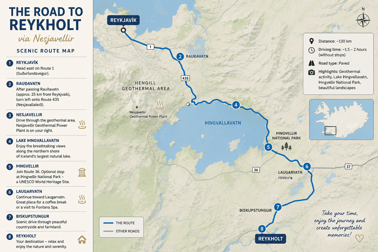
While most travelers choose the Hellisheiði route when driving from Reykjavík to Reykholt, there is another road that many consider one of the most beautiful drives in Iceland. The route through Nesjavellir and along Lake Þingvallavatn offers dramatic landscapes, peaceful surroundings, and a unique glimpse into Iceland’s remarkable natural beauty.
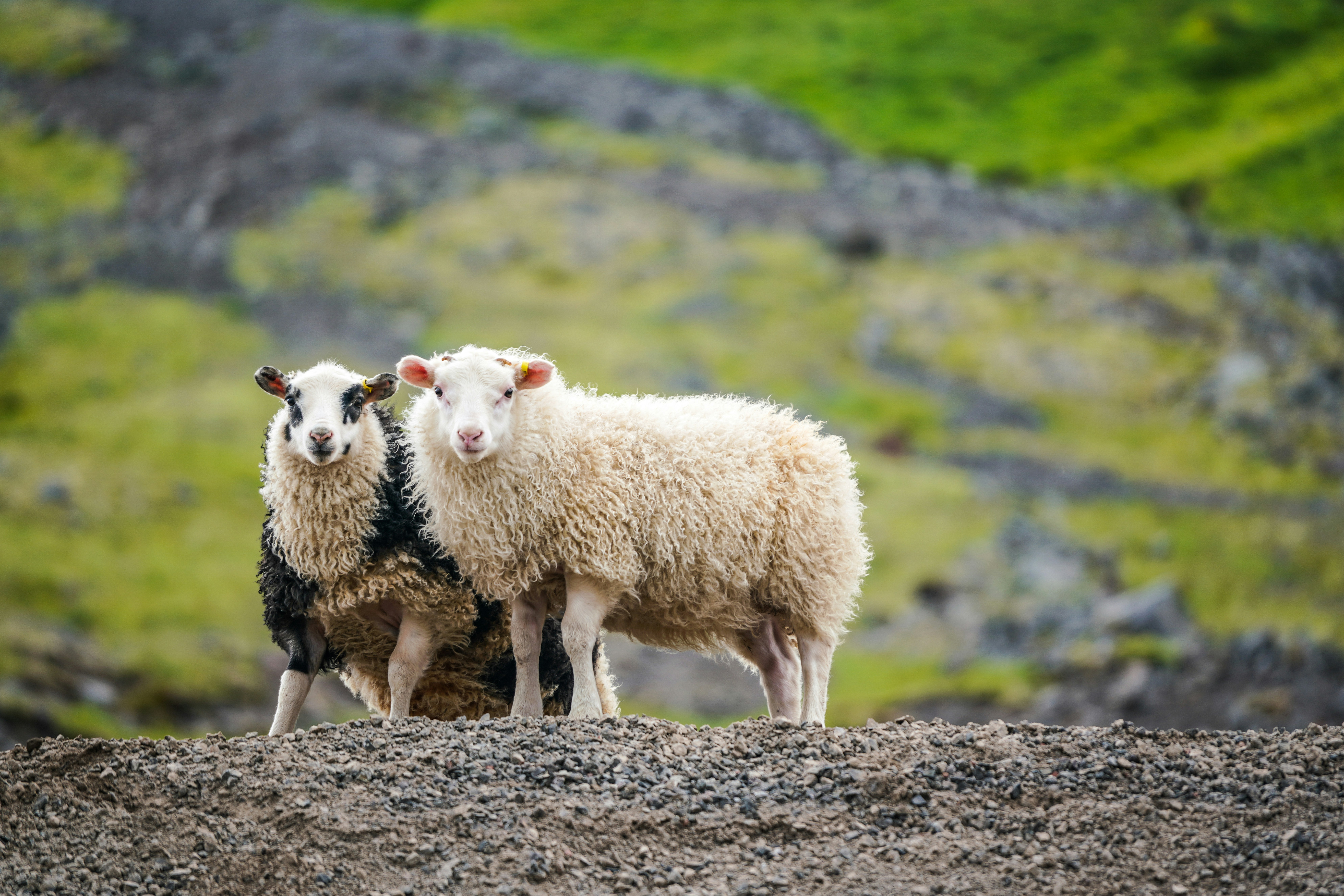
This approximately 27-kilometer route winds its way from Hólmsheiði through the Hengill geothermal area and down to Lake Þingvallavatn. Along the way, lava fields, green valleys, steaming geothermal vents, and crystal-clear water compete for your attention. For those who enjoy outdoor activities, the area is also popular for hiking and cycling.
The Hengill area itself is one of Iceland’s most popular outdoor recreation destinations. Named after Mount Hengill, an active volcanic system, the region stretches between the South Coast Road and Lake Þingvallavatn. It is famous for its geothermal activity, with steam vents, hot springs, and bubbling mud pools scattered throughout the landscape. Located on an active volcanic belt, the area also experiences frequent earthquakes. For nature lovers, it is a true paradise filled with hiking trails, spectacular mountain views, and unique geological features.
The journey begins in Reykjavík by following Route 1 eastbound. Shortly after passing Rauðavatn, turn left onto Route 435, known as the Nesjavellir Road. The atmosphere changes almost immediately. Traffic fades away, replaced by lava fields, mountains, and a sense of tranquility that feels surprisingly far removed from the capital.
Although the road is paved, it is worth noting that it is both narrow and winding. As it climbs through the lava fields, panoramic views begin to open up across vast highlands and mountain ranges. On a clear day, visibility stretches for miles, and Reykjavík slowly disappears into the rearview mirror.
One of the first things visitors notice along this route is the geothermal activity. As you approach Nesjavellir, columns of steam rise from the earth, showcasing the powerful natural forces that shape Iceland. Here you will find the Nesjavellir Geothermal Power Plant, one of the country’s largest geothermal facilities, supplying hot water and energy to much of the capital region.
Soon after, one of the highlights of the drive comes into view. Lake Þingvallavatn, Iceland’s largest natural lake, spreads out beneath the surrounding mountains. The lake constantly changes character depending on the weather and light conditions—sometimes calm and mirror-like, other times dark blue and dramatic beneath a cloudy sky.
This is a route best enjoyed at a relaxed pace. Several viewpoints along the way invite travelers to stop, take photographs, or simply appreciate the silence. During summer, the area is rich with birdlife, while autumn paints the moss and heathland in beautiful shades of red and gold.
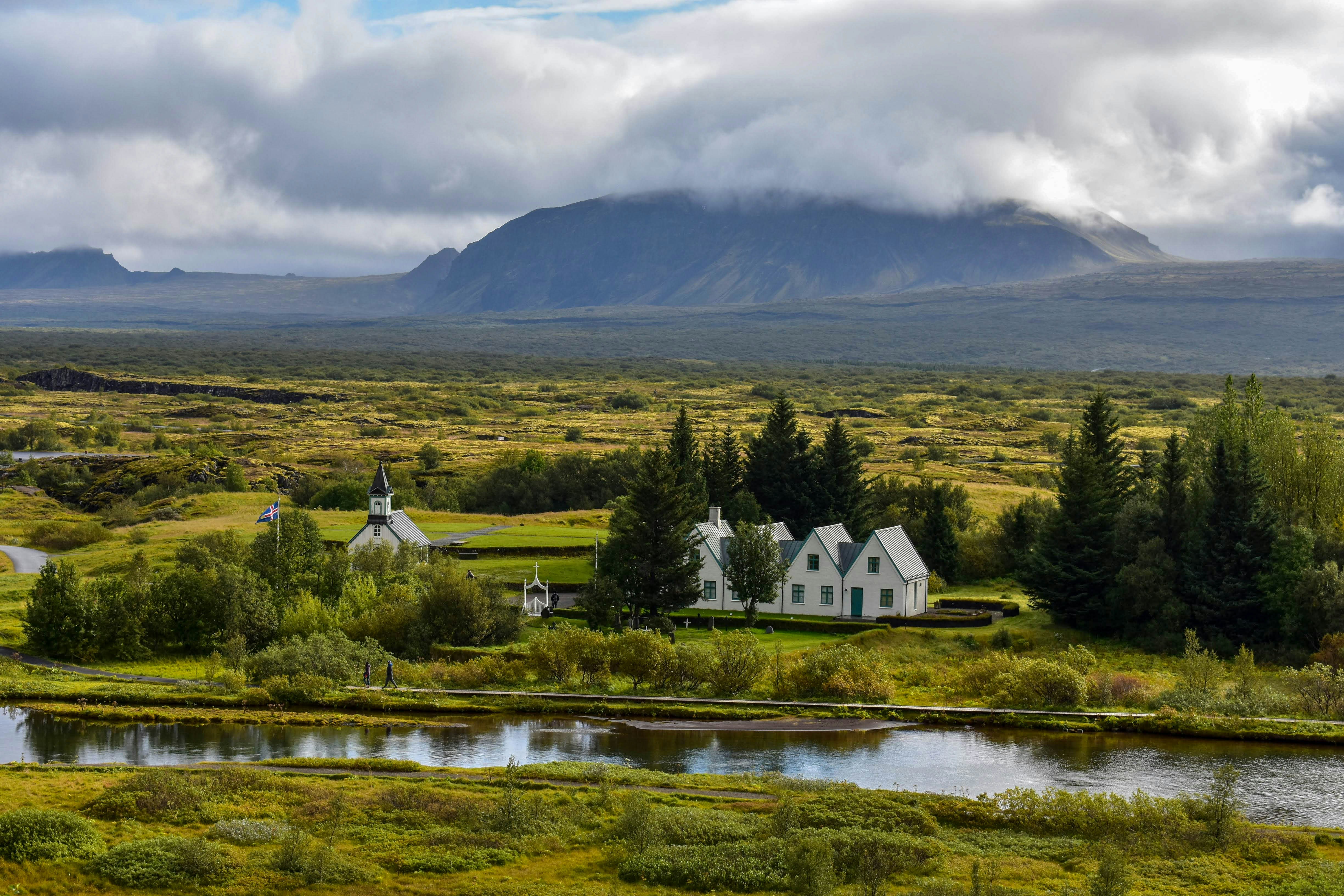
The road continues along the northern shores of Lake Þingvallavatn before joining Route 36 and entering the historic Þingvellir area. If time allows, a stop at Þingvellir National Park is highly recommended. Few places in Iceland combine history and nature so beautifully.
Even if you decide not to stop, there is plenty to see from the car. The road passes alongside the impressive cliffs of Almannagjá, where you are literally driving between the North American and Eurasian tectonic plates. Shortly afterward, you will pass the historic Þingvallakirkja church and Þingvallabær, the white buildings with green roofs situated beside the Öxará River.
As the road crosses the bridges through Þingvellir, you can also look down into the crystal-clear fissures of Silfra and Nikulásargjá, better known as Peningagjá. It is not uncommon to see divers and snorkelers exploring the famously clear glacial waters that have made Silfra world-renowned.
From Þingvellir, the journey continues toward Laugarvatn. As you descend from Laugarvatnsfjall, the village appears on your left. Approaching the town, you can often see steam rising from the geothermal area by the lake, home to Laugarvatn Fontana. The road also passes the historic old regional school, a distinctive red building that has become one of the landmarks of the village.
Beyond Laugarvatn, the drive continues into Biskupstungur. The landscape becomes increasingly green and rural as you make your way toward Reykholt.
Once you enter Biskupstungur, the pace naturally slows. Traffic is light, the air feels fresh, and the views across rivers, farmland, and distant mountains create a sense of calm that is difficult to find elsewhere. It is often at this point that travelers realize they are no longer simply heading somewhere—they have already arrived in vacation mode.
And when Reykholt finally comes into view, the journey itself has become part of the experience. All that remains is to check in, settle into your room or cottage, and enjoy everything that awaits—peaceful surroundings, beautiful nature, and perhaps a relaxing soak in a hot tub under the open Icelandic sky.
In our next blog, we will explore the third route to Reykholt, through the beautiful Mosfellsdalur valley, before taking a closer look at the many wonders that Reykholt and its surrounding area have to offer.


" width="157px"><path d="M 0 0 L 157 0 L 157 31.739 L 0 31.739 Z" fill="transparent" height="31.739242019607804px" id="XZLUe0axV" transform="translate(0 0)" width="156.9999896705932px"/><path d="M 0 0.151 L 4.244 0.151 C 5.294 0.151 6.133 0.441 6.664 0.96 C 7.081 1.388 7.286 1.895 7.286 2.529 L 7.286 2.553 C 7.286 3.604 6.718 4.189 6.061 4.557 C 7.123 4.95 7.811 5.572 7.811 6.809 L 7.811 6.833 C 7.811 8.517 6.441 9.368 4.364 9.368 L 0.006 9.368 L 0.006 0.151 Z M 5.342 2.849 C 5.342 2.227 4.847 1.859 3.96 1.859 L 1.883 1.859 L 1.883 3.912 L 3.833 3.912 C 4.757 3.912 5.342 3.598 5.342 2.873 Z M 4.28 5.529 L 1.889 5.529 L 1.889 7.66 L 4.358 7.66 C 5.294 7.66 5.867 7.316 5.867 6.61 L 5.867 6.586 C 5.867 5.928 5.372 5.535 4.286 5.535 Z M 9.362 0.151 L 11.3 0.151 L 11.3 7.6 L 15.948 7.6 L 15.948 9.374 L 9.362 9.374 Z M 16.95 5.433 L 16.95 0.151 L 18.9 0.151 L 18.9 5.366 C 18.9 6.912 19.673 7.721 20.952 7.721 C 22.232 7.721 23.017 6.948 23.017 5.439 L 23.017 0.145 L 24.954 0.145 L 24.954 5.348 C 24.954 8.137 23.397 9.501 20.928 9.501 C 18.459 9.501 16.95 8.119 16.95 5.421 Z M 26.91 0.151 L 33.84 0.151 L 33.84 1.889 L 28.836 1.889 L 28.836 3.863 L 33.242 3.863 L 33.242 5.596 L 28.836 5.596 L 28.836 7.636 L 33.9 7.636 L 33.9 9.368 L 26.91 9.368 Z M 38.591 0.151 L 40.746 0.151 L 43.226 6.761 L 45.707 0.151 L 47.808 0.151 L 44.059 9.435 L 42.339 9.435 Z M 50.977 0.085 L 52.776 0.085 L 56.742 9.368 L 54.702 9.368 L 53.838 7.268 L 49.848 7.268 L 48.985 9.368 L 46.999 9.368 Z M 53.144 5.541 L 51.852 2.415 L 50.549 5.541 Z M 57.062 4.787 L 57.062 4.763 C 57.062 2.143 59.036 0 61.861 0 C 63.593 0 64.637 0.567 65.495 1.419 L 64.251 2.849 C 63.527 2.191 62.796 1.787 61.843 1.787 C 60.249 1.787 59.096 3.115 59.096 4.739 L 59.096 4.763 C 59.096 6.386 60.225 7.739 61.843 7.739 C 62.917 7.739 63.575 7.31 64.312 6.634 L 65.555 7.89 C 64.607 8.892 63.551 9.525 61.782 9.525 C 59.072 9.525 57.056 7.437 57.056 4.787 Z M 70.239 0.085 L 72.038 0.085 L 76.004 9.368 L 73.964 9.368 L 73.1 7.268 L 69.11 7.268 L 68.247 9.368 L 66.261 9.368 Z M 72.406 5.541 L 71.114 2.415 L 69.811 5.541 Z M 78.31 1.95 L 75.473 1.95 L 75.473 0.151 L 83.085 0.151 L 83.085 1.95 L 80.26 1.95 L 80.26 9.368 L 78.31 9.368 Z M 84.606 0.151 L 86.556 0.151 L 86.556 9.368 L 84.606 9.368 Z M 88.33 4.787 L 88.33 4.763 C 88.33 2.155 90.395 0 93.232 0 C 96.069 0 98.109 2.113 98.109 4.739 L 98.109 4.763 C 98.109 7.37 96.045 9.525 93.208 9.525 C 90.371 9.525 88.33 7.413 88.33 4.787 Z M 96.069 4.787 L 96.069 4.763 C 96.069 3.139 94.88 1.787 93.208 1.787 C 91.536 1.787 90.371 3.115 90.371 4.739 L 90.371 4.763 C 90.371 6.386 91.56 7.739 93.232 7.739 C 94.904 7.739 96.069 6.411 96.069 4.787 Z M 99.799 0.151 L 101.586 0.151 L 106.029 5.964 L 106.029 0.151 L 107.954 0.151 L 107.954 9.368 L 106.294 9.368 L 101.707 3.362 L 101.707 9.368 L 99.793 9.368 L 99.793 0.151 Z M 109.427 8.028 L 110.58 6.646 C 111.413 7.34 112.289 7.787 113.369 7.787 C 114.232 7.787 114.763 7.419 114.763 6.851 L 114.763 6.827 C 114.763 6.284 114.431 6.006 112.862 5.614 C 110.973 5.143 109.796 4.612 109.796 2.801 L 109.796 2.777 C 109.796 1.129 111.136 0.03 113.013 0.03 C 114.353 0.03 115.482 0.447 116.417 1.195 L 115.391 2.662 C 114.582 2.083 113.767 1.738 112.971 1.738 C 112.174 1.738 111.727 2.131 111.727 2.602 L 111.727 2.626 C 111.727 3.26 112.132 3.477 113.755 3.893 C 115.645 4.376 116.695 5.058 116.695 6.64 L 116.695 6.664 C 116.695 8.475 115.301 9.501 113.327 9.501 C 111.92 9.501 110.526 9.018 109.427 8.034 Z M 0.012 14.753 L 0.598 14.753 L 0.598 20.832 L 0.012 20.832 Z M 2.064 17.807 L 2.064 17.789 C 2.064 16.069 3.35 14.65 5.119 14.65 C 6.211 14.65 6.869 15.043 7.491 15.61 L 7.093 16.045 C 6.568 15.544 5.982 15.175 5.113 15.175 C 3.718 15.175 2.674 16.316 2.674 17.771 L 2.674 17.789 C 2.674 19.25 3.737 20.403 5.119 20.403 C 5.97 20.403 6.537 20.071 7.141 19.491 L 7.527 19.866 C 6.881 20.512 6.193 20.928 5.101 20.928 C 3.362 20.928 2.07 19.552 2.07 17.807 Z M 8.698 14.753 L 13.063 14.753 L 13.063 15.29 L 9.278 15.29 L 9.278 17.499 L 12.664 17.499 L 12.664 18.037 L 9.278 18.037 L 9.278 20.3 L 13.099 20.3 L 13.099 20.838 L 8.692 20.838 L 8.692 14.759 Z M 14.433 14.753 L 15.018 14.753 L 15.018 20.294 L 18.508 20.294 L 18.508 20.832 L 14.433 20.832 Z M 21.966 14.711 L 22.516 14.711 L 25.311 20.832 L 24.677 20.832 L 23.94 19.178 L 20.512 19.178 L 19.769 20.832 L 19.165 20.832 L 21.96 14.711 Z M 23.711 18.652 L 22.232 15.375 L 20.747 18.652 Z M 26.469 14.753 L 27.019 14.753 L 31.009 19.811 L 31.009 14.753 L 31.576 14.753 L 31.576 20.832 L 31.117 20.832 L 27.037 15.664 L 27.037 20.832 L 26.469 20.832 Z M 33.248 14.753 L 35.325 14.753 C 37.226 14.753 38.548 16.063 38.548 17.777 L 38.548 17.795 C 38.548 19.51 37.232 20.832 35.325 20.832 L 33.248 20.832 Z M 33.834 15.284 L 33.834 20.294 L 35.325 20.294 C 36.931 20.294 37.945 19.202 37.945 17.807 L 37.945 17.789 C 37.945 16.401 36.924 15.284 35.325 15.284 Z" fill="rgb(23, 54, 69)" height="20.928100769771078px" id="UZKB9w_sz" transform="translate(40.305 6.32)" width="116.69513671589559px"/><path d="M 15.87 0 C 24.634 0 31.739 7.105 31.739 15.87 C 31.739 18.163 31.25 20.343 30.375 22.31 L 25.317 16.878 L 24.019 18.188 L 18.2 11.765 L 13.528 15.646 L 11.071 16.739 L 7.938 20.976 L 6.085 21.767 L 3.568 25.896 C 1.256 23.066 -0.004 19.523 0 15.87 C 0 7.105 7.105 0 15.87 0 Z" fill="rgb(0, 82, 130)" height="25.89603428378043px" id="bFGOksjUj" transform="translate(0 0)" width="31.739252349014983px"/><path d="M 22.902 7.183 C 20.011 11.089 15.369 13.624 10.135 13.624 C 9.869 13.624 9.61 13.618 9.344 13.606 L 11.01 5.451 L 14.644 12.604 L 15.882 8.88 L 17.409 8.155 L 16.721 3.881 L 15.006 0 L 18.64 4.225 L 22.89 7.183 Z M 8.849 13.57 C 7.529 13.463 6.227 13.191 4.974 12.761 L 8.252 0.803 L 9.055 7.431 Z M 1.394 10.66 C 0.911 10.322 0.447 9.96 0 9.58 L 1.883 5.095 L 1.394 10.666 Z" fill="rgb(23, 54, 69)" height="13.624090740652484px" id="irVY3IHy1" transform="translate(5.729 18.115)" width="22.90199380741376px"/><path d="M 15.87 0 C 24.634 0 31.739 7.105 31.739 15.87 C 31.739 18.163 31.25 20.343 30.375 22.31 L 25.317 16.878 L 24.019 18.188 L 18.2 11.765 L 13.528 15.646 L 11.071 16.739 L 7.938 20.976 L 6.085 21.767 L 3.568 25.896 C 1.256 23.066 -0.004 19.523 0 15.87 C 0 7.105 7.105 0 15.87 0 Z" fill="rgb(23, 54, 69)" height="25.89603428378043px" id="FkD3fJv03" transform="translate(0 0)" width="31.739252349014983px"/></g></svg>)